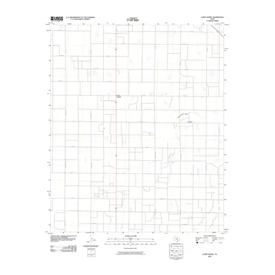
2010 Map of Lums Chapel
USGS Topo · Published 2010About this map
Lums Chapel sits at the heart of this High Plains landscape, where a rigid grid of rural roads and energy extraction define the local character. The settlement is positioned along a north-south thoroughfare, surrounded by a network of county roads named for states and cities, such as Atlanta Rd, Dallas Rd, and Maine Rd. This systematic division of the land highlights the agricultural and industrial organization of Lamb County in the early 21st century. The Anton West Oil Field occupies the eastern portion of the map, signaling the regional importance of the petroleum industry. Breaking the geometric regularity of the road grid, the ephemeral drainage of Yellow House Draw meanders across the territory, providing a natural contrast to the man-made infrastructure. This survey captures a specific era of Texas land use where traditional rural life intersects with modern resource development.
Find a feature on this map
27 named features on this map. Tap any name to fly to it.
Don’t see what you’re looking for? This feature index may not catch every label — zoom into the map to look around manually.
Map Details
Editions of this 2010 Lums Chapel Map
This is the sole edition of this map. No revisions or reprints were ever made.
Other maps of this area

1954 · Brownfield
USGS Topo · 1:250,000

1957 · Anton
USGS Topo · 1:62,500

1957 · Wolfforth
USGS Topo · 1:62,500

1958 · Brownfield
USGS Topo · 1:250,000

1962 · Brownfield
USGS Topo · 1:250,000

1964 · Oklahoma Flat
USGS Topo · 1:24,000

1964 · Littlefield
USGS Topo · 1:24,000
1964 · Bull Lake
USGS Topo · 1:24,000

1964 · Lums Chapel
USGS Topo · 1:24,000

1964 · Whitharral
USGS Topo · 1:24,000