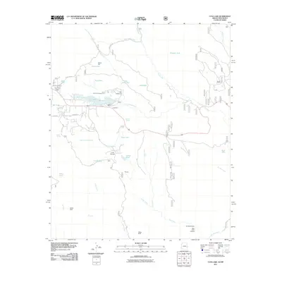
2011 Map of Luna Lake
USGS Topo · Published 2011About this map
Luna Lake serves as the central focal point of this high-altitude landscape in eastern Arizona, where the San Francisco River is controlled by the Luna Dam. The area's economic and social infrastructure is characterized by the Alpine Timber Camp and the Alpine Forest Service Facility, reflecting the importance of the surrounding national forest. Recreation and local commerce are well-documented through the presence of the Luna Lake Marina, Lake Group Campground, and the Luna Lake Campground.
Find a feature on this map
48 named features on this map. Tap any name to fly to it.
Don’t see what you’re looking for? This feature index may not catch every label — zoom into the map to look around manually.
Map Details
Editions of this 2011 Luna Lake Map
This is the sole edition of this map. No revisions or reprints were ever made.
Other maps of this area

1915 · Reserve
USGS Topo · 1:125,000

1918 · Reserve
USGS Topo · 1:125,000

1922 · Nutrioso
USGS Topo · 1:125,000

1954 · Clifton
USGS Topo · 1:250,000

1957 · Clifton
USGS Topo · 1:250,000

1958 · Clifton
USGS Topo · 1:250,000

1958 · Alpine
USGS Topo · 1:62,500

1961 · Blue
USGS Topo · 1:62,500

1962 · Clifton
USGS Topo · 1:250,000
1965 · Underwood Lake
USGS Topo · 1:24,000