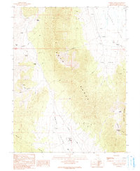
1990 Map of Lusetti Canyon
USGS Topo · Published 1991About this map
The high-desert terrain of the Egan Range dominates this 1990 survey, serving as a massive geological divide between Smith Valley to the west and Steptoe Valley to the east. Human activity in this arid landscape is defined by its water sources and ranching history, with family names marking the land at Lusetti Ranch and Kogan Place. The southern reaches of the map show the footprint of the Ely State Prison near the base of the mountains, while the surrounding area is dotted with remote resource extraction sites like the Mine Shaft and various Prospect locations. This map is particularly useful for tracing early backcountry routes such as Bothwick Road and identifying the network of springs, including McManus Spring, Archie Spring, and Jones Springs, that made life possible in the Great Basin's rugged interior.
Find a feature on this map
33 named features on this map. Tap any name to fly to it.
Don’t see what you’re looking for? This feature index may not catch every label — zoom into the map to look around manually.
Map Details
Editions of this 1990 Lusetti Canyon Map
This is the sole edition of this map. No revisions or reprints were ever made.
Other maps of this area

1952 · Ely
USGS Topo · 1:125,000

1956 · Ely
USGS Topo · 1:250,000

1958 · McGill
USGS Topo · 1:24,000

1958 · Ruth
USGS Topo · 1:24,000

1958 · East Ely
USGS Topo · 1:24,000

1958 · McGill
USGS Topo · 1:62,500

1958 · Reipetown
USGS Topo · 1:24,000

1959 · Ely
USGS Topo · 1:250,000

1959 · Reipetown
USGS Topo · 1:62,500

1963 · Ely
USGS Topo · 1:250,000