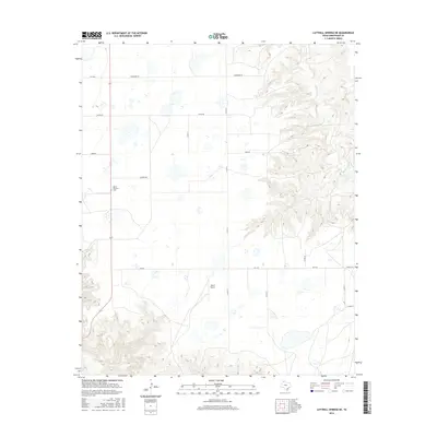
2016 Map of Luttrell Springs NE
USGS Topo · Published 2016About this map
The high plains of Armstrong County meet the dramatic incision of the Red River drainage system on this 2016 survey. The western half of the map is defined by a rigid grid of ranch roads, including November Rd, Oscar Rd, and Papa Rd, serving isolated agricultural interests. This geometric order contrasts sharply with the eastern edge of the quadrangle, where the terrain breaks into the complex canyonlands of the Mulberry Cr watershed. These deep draws and erosional features signify the edge of the Llano Estacado, where the flat tabletop of the Panhandle begins its descent. Within this sparsely populated landscape, several key landmarks anchor the area's history and infrastructure. The Mount Pleasant Cem stands as a focal point for genealogical interest, while the private Reed Airport and a network of state-maintained routes like Fm 1258 and Fm 2272 facilitate movement across this expansive ranching country.
Find a feature on this map
17 named features on this map. Tap any name to fly to it.
Don’t see what you’re looking for? This feature index may not catch every label — zoom into the map to look around manually.
Map Details
Editions of this 2016 Luttrell Springs NE Map
This is the sole edition of this map. No revisions or reprints were ever made.
Other maps of this area

1954 · Amarillo
USGS Topo · 1:250,000

1954 · Plainview
USGS Topo · 1:250,000

1958 · Amarillo
USGS Topo · 1:250,000

1958 · Plainview
USGS Topo · 1:250,000

1960 · Claude
USGS Topo · 1:62,500

1960 · Groom
USGS Topo · 1:62,500

1963 · Blue Hole Springs
USGS Topo · 1:24,000

1963 · Luttrell Springs
USGS Topo · 1:24,000

1963 · Luttrell Springs NE
USGS Topo · 1:24,000

1963 · Paloduro
USGS Topo · 1:24,000