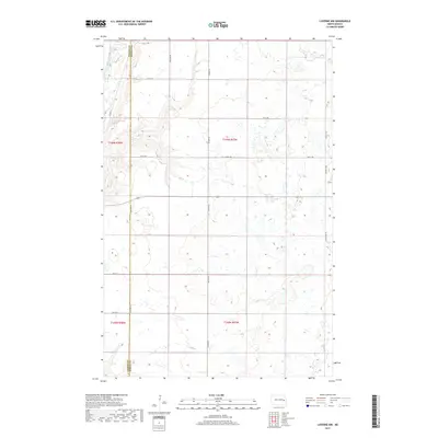
2017 Map of Luverne NW
USGS Topo · Published 2017About this map
The Sheyenne River meanders through the northwest corner of this North Dakota landscape, carving a distinct valley through the prairie terrain of Greenview Township. This 2017 survey illustrates the rigid, expansive section lines of the Public Land Survey System, defined by the meeting of Griggs and Steele Counties. The map is characterized by its agricultural grid, where rural transit depends on a network of strictly aligned roads such as Co Hwy 25 and 120th Ave NE. While the land is primarily open and dotted with small wetlands, the presence of Main St and 1st St SE at the southern margin suggests the fringe of a local settlement hub. The topography reveals the subtle glacial legacy of the region, showing how modern county boundaries and infrastructure have been laid over the natural drainage of the Sheyenne.
Find a feature on this map
20 named features on this map. Tap any name to fly to it.
Don’t see what you’re looking for? This feature index may not catch every label — zoom into the map to look around manually.
Map Details
Editions of this 2017 Luverne NW Map
This is the sole edition of this map. No revisions or reprints were ever made.
Other maps of this area

1952 · Grand Forks
USGS Topo · 1:250,000

1952 · New Rockford
USGS Topo · 1:250,000

1956 · New Rockford
USGS Topo · 1:250,000

1956 · Grand Forks
USGS Topo · 1:250,000

1961 · Cooperstown East
USGS Topo · 1:24,000

1961 · Karnak
USGS Topo · 1:24,000

1966 · Grand Forks
USGS Topo · 1:250,000

1967 · Blabon
USGS Topo · 1:24,000
1967 · Kloten SE
USGS Topo · 1:24,000

1967 · Finley
USGS Topo · 1:24,000