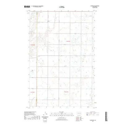
2020 Map of Luverne NW
USGS Topo · Published 2020About this map
The Sheyenne River cuts through the northwest corner of this prairie landscape, defining the northern boundary between Griggs and Steele counties. This 2020 survey of the Greenview Township area reveals a highly organized section-line road network typical of the Red River Valley hinterlands. The rural character of the region is anchored by several established burial grounds, including Sheyenne Valley Cem and Opheim Cem, which serve as physical markers of the homesteading families who settled these sections. The map detail shows a terrain dotted with numerous small wetlands and prairie potholes, particularly visible in the central and eastern portions. Local transit is facilitated by arterial routes such as Co Hwy 25, which bisects the quadrangle vertically, and secondary roads like 3rd St NE and 4th St NE that provide access to the dispersed farmsteads and agricultural plots.
Find a feature on this map
24 named features on this map. Tap any name to fly to it.
Don’t see what you’re looking for? This feature index may not catch every label — zoom into the map to look around manually.
Map Details
Editions of this 2020 Luverne NW Map
This is the sole edition of this map. No revisions or reprints were ever made.
Other maps of this area

1952 · Grand Forks
USGS Topo · 1:250,000

1952 · New Rockford
USGS Topo · 1:250,000

1956 · New Rockford
USGS Topo · 1:250,000

1956 · Grand Forks
USGS Topo · 1:250,000

1961 · Cooperstown East
USGS Topo · 1:24,000

1961 · Karnak
USGS Topo · 1:24,000

1966 · Grand Forks
USGS Topo · 1:250,000

1967 · Blabon
USGS Topo · 1:24,000
1967 · Kloten SE
USGS Topo · 1:24,000

1967 · Finley
USGS Topo · 1:24,000