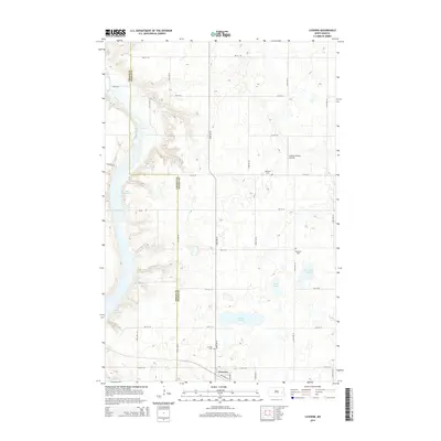
2014 Map of Luverne
USGS Topo · Published 2014About this map
Luverne anchors this Steele County landscape at a time when the prairie was defined by its water and agricultural grid. The Sheyenne River winds through the western portion of the quadrangle, forming the northern reaches of Lake Ashtabula. This reservoir, created by the Baldhill Dam, dominates the river valley, while the surrounding uplands are dotted with smaller prairie potholes like Willow Lake, Stony Lake, and Lone Tree Lake. The town itself is situated along Railroad Ave at the intersection with Paulson St, serving as a central hub for the section-line road network. Genealogists and local researchers will find several family-named landmarks and burial sites, including the Peterson Cem, Pederson Cem, and the Luverne Cem just north of town. The presence of the Johnson Private Airstrip north of 6th St SE reflects the modern aviation needs of this rural farming community.
Find a feature on this map
30 named features on this map. Tap any name to fly to it.
Don’t see what you’re looking for? This feature index may not catch every label — zoom into the map to look around manually.
Map Details
Editions of this 2014 Luverne Map
This is the sole edition of this map. No revisions or reprints were ever made.
Other maps of this area

1952 · Grand Forks
USGS Topo · 1:250,000

1952 · New Rockford
USGS Topo · 1:250,000

1956 · New Rockford
USGS Topo · 1:250,000

1956 · Grand Forks
USGS Topo · 1:250,000

1961 · Cooperstown East
USGS Topo · 1:24,000

1961 · Dazey NE
USGS Topo · 1:24,000

1961 · Karnak
USGS Topo · 1:24,000

1966 · Grand Forks
USGS Topo · 1:250,000

1967 · Blabon
USGS Topo · 1:24,000
1967 · Luverne
USGS Topo · 1:24,000