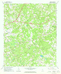
1963 Map of Luxomni
USGS Topo · Published 1972About this map
Luxomni and surrounding Gwinnett County rural communities appear here just as suburban expansion began to reach beyond Lawrenceville. The landscape is a complex network of family-named landmarks and country congregations, from McKendree Ch in the north to Friendship Ch at Five Forks. This era shows a transitional geography where agricultural roots remained visible through features like the Lebanon Cem and numerous small impoundments such as Lake Atha, Newton Lake, and Lake Matthews. The Seaboard Air Line railroad and the burgeoning Northeast Expressway cut through the terrain, signaling the rapid transformation of places like Gloster and Bethesda from quiet crossroads into connected transit corridors. Significant watercourses like Sweetwater Creek and the Yellow River provide the natural structure for a region moving toward its modern identity while still retaining its local-history markers.
Find a feature on this map
55 named features on this map. Tap any name to fly to it.
Don’t see what you’re looking for? This feature index may not catch every label — zoom into the map to look around manually.
Map Details
Editions of this 1963 Luxomni Map
4 editions found
Other maps of this area

1888 · Atlanta
USGS Topo · 1:125,000

1890 · Suwanee
USGS Topo · 1:125,000

1890 · Atlanta
USGS Topo · 1:125,000

1891 · Gainesville
USGS Topo · 1:125,000

1892 · Atlanta
USGS Topo · 1:125,000

1894 · Suwanee
USGS Topo · 1:125,000

1895 · Atlanta
USGS Topo · 1:125,000

1896 · Monroe
USGS Topo · 1:125,000

1953 · Atlanta
USGS Topo · 1:250,000

1953 · Athens
USGS Topo · 1:250,000