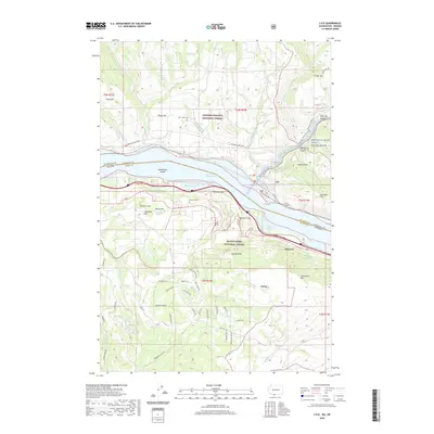
2020 Map of Lyle
USGS Topo · Published 2020About this map
Lake Bonneville dominates the center of this survey, where the Washington and Oregon border follows the water's path through the Columbia River Gorge. The settlement of Lyle sits on the northern bank at the mouth of the Klickitat River, while across the water, the unincorporated community of Rowena and the site of Ortley are positioned below the dramatic height of Rowena Crest. The landscape is a study in verticality, from the shoreline of Salisbury Slough to the protected terrain of McCall Point within the Mount Hood National Forest. Local history and genealogy are anchored by specific landmarks like Memaloose Island and the Lyle - Balch Cem, which contrast with the modern recreational footprint of the Klickitat State Park Trail. This area's geography is defined by its canyons and hills, including Mud Spring Canyon and the Columbia Hills, which have dictated the placement of roads and early homesteads for generations.
Find a feature on this map
74 named features on this map. Tap any name to fly to it.
Don’t see what you’re looking for? This feature index may not catch every label — zoom into the map to look around manually.
Map Details
Editions of this 2020 Lyle Map
This is the sole edition of this map. No revisions or reprints were ever made.
Other maps of this area

1934 · The Dalles
USGS Topo · 1:125,000

1953 · The Dalles
USGS Topo · 1:250,000

1956 · The Dalles
USGS Topo · 1:250,000

1957 · The Dalles
USGS Topo · 1:250,000

1957 · Klickitat
USGS Topo · 1:62,500

1957 · The Dalles
USGS Topo · 1:62,500

1957 · White Salmon
USGS Topo · 1:62,500

1957 · Husum
USGS Topo · 1:62,500

1974 · The Dalles North
USGS Topo · 1:24,000
1974 · Brown Creek
USGS Topo · 1:24,000