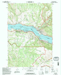
1994 Map of Lyle
USGS Topo · Published 1996About this map
Lyle sits at the confluence of the Klickitat River and the Columbia River, serving as a vital focal point where rail and river traffic intersect. This mid-1990s revision reveals a landscape heavily shaped by both natural drainage and human industry, with numerous quarries and borrow pits scattered across the surrounding hills. The map highlights the complex boundaries between Washington and Oregon, marked by the river's path and several protected areas including Memaloose State Park and Mayer State Park. Significant landmarks like Memaloose Island and the Lyle Cemetery provide touchstones for local history, while the presence of the Landing Strip and Radio Facility points toward modern infrastructure. High-altitude features like Sevenmile Hill and the Columbia Hills rise sharply from the water, framing the Columbia River Gorge National Scenic Area and the Gifford Pinchot National Forest.
Find a feature on this map
59 named features on this map. Tap any name to fly to it.
Don’t see what you’re looking for? This feature index may not catch every label — zoom into the map to look around manually.
Map Details
Editions of this 1994 Lyle Map
This is the sole edition of this map. No revisions or reprints were ever made.
Other maps of this area

1934 · The Dalles
USGS Topo · 1:125,000

1953 · The Dalles
USGS Topo · 1:250,000

1956 · The Dalles
USGS Topo · 1:250,000

1957 · The Dalles
USGS Topo · 1:250,000

1957 · Klickitat
USGS Topo · 1:62,500

1957 · The Dalles
USGS Topo · 1:62,500

1957 · White Salmon
USGS Topo · 1:62,500

1957 · Husum
USGS Topo · 1:62,500

1974 · The Dalles North
USGS Topo · 1:24,000
1974 · Brown Creek
USGS Topo · 1:24,000