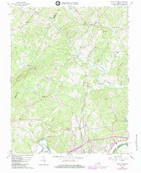
1966 Map of Lynch Station
USGS Topo · Published 1984About this map
The Southern railway line serves as a central artery through this rural landscape, connecting the settlements of Lynch Station and Evington. Situated between the Big Otter River and the Roanoke River, the terrain is defined by its numerous small valleys carved by Mill Creek and Johnson Creek. The map reveals a dense network of country churches that anchored community life in the mid-1960s, including Mt Pisgah Ch, Good Shepherd Ch, and Mt Hermon Ch. Mineral extraction activity is evident from the Mines located near Flat Creek, while higher elevations like Johnson Mountain are marked by communication infrastructure, including a Radio Tower (WLVA). Near the southern boundary, the confluence of the Southern and Norfolk and Western railroads highlights the region's historic role as a transportation corridor between Campbell and Pittsylvania counties.
Find a feature on this map
47 named features on this map. Tap any name to fly to it.
Don’t see what you’re looking for? This feature index may not catch every label — zoom into the map to look around manually.
Map Details
Editions of this 1966 Lynch Station Map
4 editions found
Other maps of this area

1892 · Lynchburg
USGS Topo · 1:125,000

1944 · Lynchburg
USGS Topo · 1:62,500

1947 · Roanoke
USGS Topo · 1:250,000

1950 · Goode
USGS Topo · 1:62,500

1950 · Lynchburg
USGS Topo · 1:62,500

1951 · Altavista
USGS Topo · 1:62,500

1956 · Gladys
USGS Topo · 1:62,500

1959 · Roanoke
USGS Topo · 1:250,000

1963 · Roanoke
USGS Topo · 1:250,000

1963 · City Farm
USGS Topo · 1:24,000