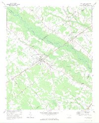
1973 Map of Lynchburg
USGS Topo · Published 1975About this map
Lynches River winds through the heart of this landscape, its wide floodplain defining the border between Lee, Darlington, and Florence counties. The settlement at Lynchburg and its southern neighbor South Lynchburg serve as the primary hubs, surrounded by a rural network of churches and family cemeteries that anchor the local history. Several historic transportation corridors converge here, including the Seaboard Coast Line railroad and the Old Stagecoach Road, which suggest the area's long-standing role as a transit point through the South Carolina interior.
Find a feature on this map
44 named features on this map. Tap any name to fly to it.
Don’t see what you’re looking for? This feature index may not catch every label — zoom into the map to look around manually.
Map Details
Editions of this 1973 Lynchburg Map
This is the sole edition of this map. No revisions or reprints were ever made.
Other maps of this area

1920 · Mayesville
USGS Topo · 1:48,000

1921 · Mayesville
USGS Topo · 1:62,500

1940 · Florence West
USGS Topo · 1:62,500

1941 · Spartanburg
USGS Topo · 1:250,000

1943 · Mayesville
USGS Topo · 1:62,500

1945 · Florence West
USGS Topo · 1:62,500

1946 · Lake City
USGS Topo · 1:62,500

1949 · Georgetown
USGS Topo · 1:250,000

1953 · Florence
USGS Topo · 1:250,000

1953 · Spartanburg
USGS Topo · 1:250,000