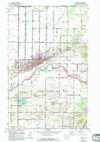
1952 Map of Lynden
USGS Topo · Published 1995About this map
The Nooksack River anchors this detailed study of northern Whatcom County, showing the agricultural and civic growth of the region. Just south of the international border where the US Custom House stands, the landscape transitions from the open Prairie into the organized grid of Lynden, featuring the Lynden High Sch and a municipal Lynden Airport. The map reveals a land defined by its water, from the winding Fishtrap Creek and Pepin Creek to recreational spots like Bartlett Beach on Wiser Lake. Smaller settlements and gathering points like Northwood, Greenwood, and the Tenmile Grange illustrate the social fabric of the rural community. Genealogists will find significant detail in the multiple burial sites, including the Lynden Cem, Greenwood Cemetery, and the Indian Joe Cemetery, providing a clear look at local settlement patterns and family heritage.
Find a feature on this map
39 named features on this map. Tap any name to fly to it.
Don’t see what you’re looking for? This feature index may not catch every label — zoom into the map to look around manually.
Map Details
Editions of this 1952 Lynden Map
3 editions found
Other maps of this area

1906 · Sumas
USGS Topo · 1:62,500

1907 · Blaine
USGS Topo · 1:62,500

1908 · Sumas
USGS Topo · 1:62,500

1952 · Bertrand Creek
USGS Topo · 1:24,000

1952 · Lynden
USGS Topo · 1:24,000

1952 · Lawrence
USGS Topo · 1:24,000

1952 · Sumas
USGS Topo · 1:24,000

1952 · Ferndale
USGS Topo · 1:24,000

1952 · Blaine
USGS Topo · 1:62,500

1954 · Bellingham North
USGS Topo · 1:24,000