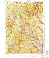
1939 Map of Lyndonville
USGS Topo · Published 1939About this map
Lyndonville and the surrounding villages of the Passumpsic River valley are shown during the mid-1930s, a period when the timber and agricultural economy of the Northeast Kingdom relied heavily on the Canadian Pacific railroad. The map documents an extensive network of rural district schools, including the Old Red Sch, Mosquito Sch, and Pudding Hill Sch, many of which served isolated hillside farming communities. Near the northern edge, the dramatic gap formed by Mt Pisgah and Mt Hor frames Lake Willoughby. Evidence of New Deal-era labor is visible at the Summit CCC Camp near the Sutton town line. Small-scale manufacturing and industry are represented by sites such as Ranney's Mills and a Gravel Pit near Lyndon Center, illustrating the decentralized local infrastructure that preceded modern consolidation.
Find a feature on this map
130 named features on this map. Tap any name to fly to it.
Don’t see what you’re looking for? This feature index may not catch every label — zoom into the map to look around manually.
Map Details
Editions of this 1939 Lyndonville Map
3 editions found

Other maps of this area

1919 · Lake Memphremagog
USGS Topo · 1:62,500

1920 · Derby
USGS Topo · 1:62,500

1920 · Irasburg
USGS Topo · 1:62,500

1923 · Irasburg
USGS Topo · 1:48,000

1923 · Lake Memphremagog
USGS Topo · 1:48,000

1924 · Island Pond
USGS Topo · 1:48,000

1925 · Irasburg
USGS Topo · 1:62,500

1925 · Memphremagog
USGS Topo · 1:62,500

1926 · Island Pond
USGS Topo · 1:62,500

1928 · Hardwick
USGS Topo · 1:62,500