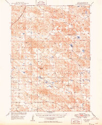
1949 Map of Lynn
USGS Topo · Published 1949About this map
Lynn and the surrounding rangelands of Morrill County are documented here in a post-war survey focused on the development of the Missouri River Basin. The landscape is characterized by a high density of small water bodies and alkali basins, including Bignell Lake, Smith Lake, and Rush Lake, interspersed with prominent landmarks like Cowboy Hill and Reilly Hill. The cattle ranching economy is evident through features like the Smith Ranch and numerous isolated windmills that dot the terrain to provide water for livestock.
Find a feature on this map
29 named features on this map. Tap any name to fly to it.
Don’t see what you’re looking for? This feature index may not catch every label — zoom into the map to look around manually.
Map Details
Editions of this 1949 Lynn Map
2 editions found
Other maps of this area

1896 · Browns Creek
USGS Topo · 1:125,000

1898 · Camp Clarke
USGS Topo · 1:125,000

1899 · Browns Creek
USGS Topo · 1:125,000

1947 · Alliance
USGS Topo · 1:24,000

1947 · Bronco Lake
USGS Topo · 1:24,000

1948 · Hemingford 4 SE
USGS Topo · 1:24,000

1948 · Alliance
USGS Topo · 1:24,000

1948 · Antioch
USGS Topo · 1:62,500

1949 · Lynn
USGS Topo · 1:62,500
1949 · Bronco Lake
USGS Topo · 1:24,000