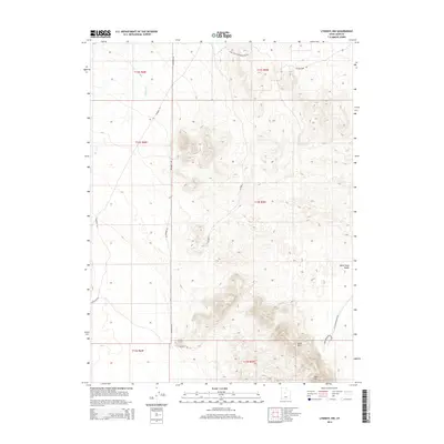
2014 Map of Lynndyl NW
USGS Topo · Published 2014About this map
White Sand Dunes and the dramatic topography of the Sand Hills dominate this portion of the Sevier Desert landscape in western Utah. The terrain is defined by shifting aeolian features and seasonal drainages like Cherry Creek, which cuts through the northwestern sections. Human movement through this arid environment is traced by a network of unpaved corridors, most notably the Little Sahara Main Road and Sand Mountain Road, providing access to the recreation-heavy dune fields. Historical infrastructure is evidenced by the long straightaways of Telephone Road and Windmill Road, which hint at early 20th-century communication and ranching utility. The map details the complex contouring of Sand Mountain, showing the significant elevations that characterize this well-known geological and recreational landmark.
Find a feature on this map
17 named features on this map. Tap any name to fly to it.
Don’t see what you’re looking for? This feature index may not catch every label — zoom into the map to look around manually.
Map Details
Editions of this 2014 Lynndyl NW Map
This is the sole edition of this map. No revisions or reprints were ever made.
Other maps of this area

1885 · Sevier Desert
USGS Topo · 1:250,000

1953 · Delta
USGS Topo · 1:250,000

1958 · Delta
USGS Topo · 1:250,000

1962 · Delta
USGS Topo · 1:250,000

1962 · Lynndyl
USGS Topo · 1:62,500

1963 · Maple Peak
USGS Topo · 1:24,000

1963 · Cherry Creek
USGS Topo · 1:24,000

1971 · Rain Lake
USGS Topo · 1:24,000

1971 · Desert Mtn Pass
USGS Topo · 1:24,000
1971 · Desert Mtn Reservoir
USGS Topo · 1:24,000