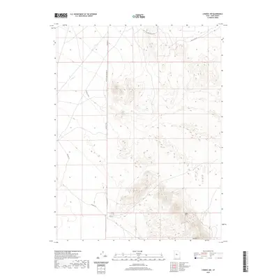
2020 Map of Lynndyl NW
USGS Topo · Published 2020About this map
Sand Mtn and the Sand Hills dominate the southeastern landscape of this Juab County desert region, where the terrain shifts from high-relief sandy dunes to open flats. This 2020 map documents a sophisticated network of desert access points, characterized by utility-focused routes like Telephone Rd and Windmill Rd, which trace the path of ranching infrastructure and early communications lines through the arid basin. The intermittent Cherry Cr provides a rare drainage feature in the northwest corner, cutting through an area marked by a series of numbered windmills and access roads. The geography here is defined by industrial and recreational access, with specifically named corridors like Left Fork Sand Mountain Rd and Backside Sand Mountain Rd providing waypoints for modern navigation through the shifting sands of the West Desert.
Find a feature on this map
10 named features on this map. Tap any name to fly to it.
Don’t see what you’re looking for? This feature index may not catch every label — zoom into the map to look around manually.
Map Details
Editions of this 2020 Lynndyl NW Map
This is the sole edition of this map. No revisions or reprints were ever made.
Other maps of this area

1885 · Sevier Desert
USGS Topo · 1:250,000

1953 · Delta
USGS Topo · 1:250,000

1958 · Delta
USGS Topo · 1:250,000

1962 · Delta
USGS Topo · 1:250,000

1962 · Lynndyl
USGS Topo · 1:62,500

1963 · Maple Peak
USGS Topo · 1:24,000

1963 · Cherry Creek
USGS Topo · 1:24,000

1971 · Rain Lake
USGS Topo · 1:24,000

1971 · Desert Mtn Pass
USGS Topo · 1:24,000
1971 · Desert Mtn Reservoir
USGS Topo · 1:24,000