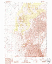
1986 Map of Lynndyl NW
USGS Topo · Published 1986About this map
Little Sahara National Recreation Area dominates this high-desert landscape in west-central Utah, where the terrain is defined by an extensive system of dunes and peaks. The topography is anchored by Sand Mountain in the southeast and the wide expanse of the Sand Hills, illustrating the shifting nature of this arid environment during the mid-1980s. Water is scarce in this portion of the Utah-Juab Co. border region, with Cherry Creek providing one of the few named drainage features in the northwest corner. A lone Water Tank stands as a point of human infrastructure amid the natural landscape. This provisional survey provides an exacting look at the elevation contours and landform distribution of the Sevier Desert before modern recreational usage patterns were fully established.
Find a feature on this map
7 named features on this map. Tap any name to fly to it.
Don’t see what you’re looking for? This feature index may not catch every label — zoom into the map to look around manually.
Map Details
Editions of this 1986 Lynndyl NW Map
This is the sole edition of this map. No revisions or reprints were ever made.
Other maps of this area

1885 · Sevier Desert
USGS Topo · 1:250,000

1953 · Delta
USGS Topo · 1:250,000

1958 · Delta
USGS Topo · 1:250,000

1962 · Delta
USGS Topo · 1:250,000

1962 · Lynndyl
USGS Topo · 1:62,500

1963 · Maple Peak
USGS Topo · 1:24,000

1963 · Cherry Creek
USGS Topo · 1:24,000

1971 · Rain Lake
USGS Topo · 1:24,000

1971 · Desert Mtn Pass
USGS Topo · 1:24,000
1971 · Desert Mtn Reservoir
USGS Topo · 1:24,000