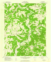
1961 Map of Lynx
USGS Topo · Published 1962About this map
Lynx and the surrounding townships of Tiffin, Meigs, and Oliver are defined by the winding course of Brush Creek, which carves through the landscape of the Virginia Military District. In the early 1960s, this area of Adams County maintained a traditional rural structure centered on small settlements like Dunkinsville and Cedar Mills. The map reveals a high density of community landmarks that served a dispersed population, including the Stonewall Grange Hall, Township School, and numerous country churches such as Stone Chapel and Liberty Chapel.
Find a feature on this map
77 named features on this map. Tap any name to fly to it.
Don’t see what you’re looking for? This feature index may not catch every label — zoom into the map to look around manually.
Map Details
Editions of this 1961 Lynx Map
3 editions found
Other maps of this area

1916 · Peebles
USGS Topo · 1:62,500

1918 · Peebles
USGS Topo · 1:62,500

1918 · Seaman
USGS Topo · 1:62,500

1919 · Vanceburg
USGS Topo · 1:62,500

1929 · Springdale
USGS Topo · 1:48,000

1935 · Springdale
USGS Topo · 1:62,500

1949 · Vanceburg
USGS Topo · 1:62,500

1949 · Buena Vista
USGS Topo · 1:24,000

1949 · Concord
USGS Topo · 1:24,000
1951 · Buena Vista
USGS Topo · 1:24,000