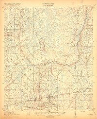
1918 Map of Macclenny
USGS Topo · Published 1918About this map
Macclenny serves as the focal point of this 1917 survey, situated at the junction of the Seaboard Airline railway and the Jacksonville Road. The surrounding landscape is defined by the prominent elevation of Trail Ridge, which provides a topographical backbone above the complex hydrologic networks of Barber Bay and the winding St Marys River at the Georgia-Florida border.
Find a feature on this map
80 named features on this map. Tap any name to fly to it.
Don’t see what you’re looking for? This feature index may not catch every label — zoom into the map to look around manually.
Map Details
Editions of this 1918 Macclenny Map
4 editions found
Other maps of this area

1917 · Cambon
USGS Topo · 1:62,500

1917 · Macclenny
USGS Topo · 1:62,500

1917 · Hilliard
USGS Topo · 1:62,500

1918 · Middleburg
USGS Topo · 1:62,500

1918 · Moniac
USGS Topo · 1:62,500

1918 · Lawtey
USGS Topo · 1:62,500

1918 · Cambon
USGS Topo · 1:62,500

1918 · Macclenny
USGS Topo · 1:62,500

1919 · Hilliard
USGS Topo · 1:62,500

1941 · Middleburg
USGS Topo · 1:62,500