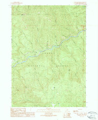
1989 Map of Mace Mountain
USGS Topo · Published 1990About this map
The North Fork Umpqua River carves a central path through this section of the Umpqua National Forest, defining a landscape of steep drainages and prominent peaks. Recorded during the late 1980s, the map highlights the rugged topography around Mace Mountain and Thunder Mountain. The river corridor is the primary focus for human activity, shown through the Mc Donald Homestead and recreation sites like the Bogus Creek Campground and Fall Creek Picnic Area. Several waterfalls, including Emile Falls and Grotto Falls, are identified along the southern creeks. The presence of numerous 4wd tracks and a Borrow Pit suggests the ongoing importance of forest management and access roads in this Douglas County backcountry, while named features like Jobs Garden and Blitzen Butte provide specific points of interest for local history and geographic study.
Find a feature on this map
42 named features on this map. Tap any name to fly to it.
Don’t see what you’re looking for? This feature index may not catch every label — zoom into the map to look around manually.
Map Details
Editions of this 1989 Mace Mountain Map
This is the sole edition of this map. No revisions or reprints were ever made.
Other maps of this area

1955 · Quartz Mtn
USGS Topo · 1:62,500

1955 · Red Butte
USGS Topo · 1:62,500

1955 · Mace Mtn
USGS Topo · 1:62,500

1955 · Illahee Rock
USGS Topo · 1:62,500

1958 · Roseburg
USGS Topo · 1:250,000

1959 · Roseburg
USGS Topo · 1:250,000

1978 · Diamond Lake
USGS Topo · 1:100,000
1989 · Taft Mountain
USGS Topo · 1:24,000
1989 · Scaredman Creek
USGS Topo · 1:24,000
1989 · Old Fairview
USGS Topo · 1:24,000