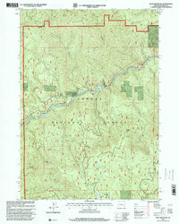
1997 Map of Mace Mountain
USGS Topo · Published 2000About this map
The North Fork Umpqua River carves a deep path through this heavily forested section of Douglas County, defining the landscape with a series of rapids and steep drainage basins. Within the Umpqua National Forest, the terrain rises sharply from the riverbanks toward high peaks like Mace Mountain and Thunder Mountain. Cultural landmarks are sparse but significant, including the Mc Donald Homestead and Jobs Garden, which suggest early human activity and land claims in an otherwise difficult-to-reach wilderness. Several quarries are noted along the periphery, pointing to the region's extraction history and road-building efforts within the timberlands. Notable water features like Grotto Falls and Emile Falls emphasize the dramatic verticality of the Emile Creek drainage, while facilities such as Willow Flats Camp and a remote Shelter near Cougar Bluffs indicate the area's use for forest management and recreation in the late 20th century.
Find a feature on this map
39 named features on this map. Tap any name to fly to it.
Don’t see what you’re looking for? This feature index may not catch every label — zoom into the map to look around manually.
Map Details
Editions of this 1997 Mace Mountain Map
This is the sole edition of this map. No revisions or reprints were ever made.
Other maps of this area

1955 · Quartz Mtn
USGS Topo · 1:62,500

1955 · Red Butte
USGS Topo · 1:62,500

1955 · Mace Mtn
USGS Topo · 1:62,500

1955 · Illahee Rock
USGS Topo · 1:62,500

1958 · Roseburg
USGS Topo · 1:250,000

1959 · Roseburg
USGS Topo · 1:250,000

1978 · Diamond Lake
USGS Topo · 1:100,000
1989 · Taft Mountain
USGS Topo · 1:24,000
1989 · Scaredman Creek
USGS Topo · 1:24,000
1989 · Old Fairview
USGS Topo · 1:24,000