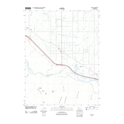
2010 Map of Mack
USGS Topo · Published 2010About this map
Loma and Mack serve as the primary anchors for this high-desert landscape, where the agricultural legacy of the Grand Valley meets the dramatic sandstone topography of the Colorado Plateau. The northern half of the region is defined by an intricate network of irrigation, including the Grand Valley Canal and the Loma Drain, supporting local farming near the settlements. This engineered water system contrasts sharply with the southern terrain, where the Colorado River carves through deep sandstone breaks. South of the river, the land rises into a complex of drainages like Rattlesnake Canyon and Pollock Canyon, notable for a high concentration of natural features such as Centennial Arch, Cedar Tree Arch, and Window Rock Tower. The map traces the transition from the industrial activity at Gilsonite to the wilder reaches of Horsethief Canyon, illustrating how the geography of Mesa County dictates both the path of the Interstate and the preservation of these geological landmarks.
Find a feature on this map
60 named features on this map. Tap any name to fly to it.
Don’t see what you’re looking for? This feature index may not catch every label — zoom into the map to look around manually.
Map Details
Editions of this 2010 Mack Map
This is the sole edition of this map. No revisions or reprints were ever made.
Other maps of this area

1934 · Colorado National Monument
USGS Topo · 1:24,000

1956 · Grand Junction
USGS Topo · 1:250,000

1959 · Grand Junction
USGS Topo · 1:250,000

1960 · Grand Junction
USGS Topo · 1:250,000

1962 · Grand Junction
USGS Topo · 1:250,000

1962 · Fruita
USGS Topo · 1:24,000

1962 · Mack
USGS Topo · 1:24,000

1962 · Colorado National Monument
USGS Topo · 1:24,000
1962 · Battleship Rock
USGS Topo · 1:24,000

1964 · Grand Junction
USGS Topo · 1:250,000