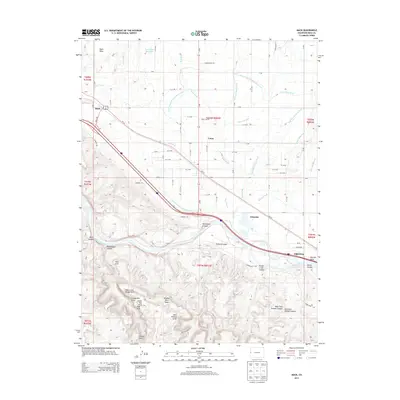
2013 Map of Mack
USGS Topo · Published 2013About this map
Fruita and the surrounding agricultural corridor of Mesa County are defined by an intricate network of irrigation systems and dramatic sandstone topography. This landscape is anchored by the Colorado River, which carved the deep incisions of Horsethief Canyon and Rattlesnake Canyon. North of the river, the human footprint is shaped by water engineering, with the Grand Valley Canal and Kiefer Extension Grand Valley Canal supporting the settlements of Mack, Loma, and Gilsonite. The southern portion of the map transitions into a high-desert wilderness characterized by unique geological formations, including Window Rock Tower, Centennial Arch, and Trail Arch. This juxtaposition between the fertile, canal-fed valley and the arid canyonlands reveals the critical role of water management in sustaining Colorado's western slope communities.
Find a feature on this map
60 named features on this map. Tap any name to fly to it.
Don’t see what you’re looking for? This feature index may not catch every label — zoom into the map to look around manually.
Map Details
Editions of this 2013 Mack Map
This is the sole edition of this map. No revisions or reprints were ever made.
Other maps of this area

1934 · Colorado National Monument
USGS Topo · 1:24,000

1956 · Grand Junction
USGS Topo · 1:250,000

1959 · Grand Junction
USGS Topo · 1:250,000

1960 · Grand Junction
USGS Topo · 1:250,000

1962 · Grand Junction
USGS Topo · 1:250,000

1962 · Fruita
USGS Topo · 1:24,000

1962 · Mack
USGS Topo · 1:24,000

1962 · Colorado National Monument
USGS Topo · 1:24,000
1962 · Battleship Rock
USGS Topo · 1:24,000

1964 · Grand Junction
USGS Topo · 1:250,000