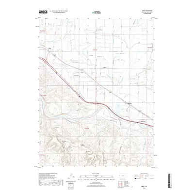
2019 Map of Mack
USGS Topo · Published 2019About this map
Grand Valley agriculture meets the high desert wilderness in this detailed survey of Western Colorado. The irrigation network, including the Grand Valley Canal and Golden Hill Canal, supports the settlements of Mack, Loma, and the western edge of Fruita. North of the valley, Mack Mesa and its Mack Mesa Reservoir overlook the cultivated plains. To the south, the terrain shifts abruptly at the Colorado River, giving way to a dense concentration of geological landmarks within the Horsethief Canyon SWA. This area is particularly notable for its high density of named natural arches, such as Trail Arch, Centennial Arch, and the Hole in the Bridge Arch. The map captures the intersection of the region's ranching and farming identity with its transition into the canyons of Rattlesnake Canyon and Pollock Canyon, providing a clear record of the modern road grid alongside these ancient landforms.
Find a feature on this map
79 named features on this map. Tap any name to fly to it.
Don’t see what you’re looking for? This feature index may not catch every label — zoom into the map to look around manually.
Map Details
Editions of this 2019 Mack Map
This is the sole edition of this map. No revisions or reprints were ever made.
Other maps of this area

1934 · Colorado National Monument
USGS Topo · 1:24,000

1956 · Grand Junction
USGS Topo · 1:250,000

1959 · Grand Junction
USGS Topo · 1:250,000

1960 · Grand Junction
USGS Topo · 1:250,000

1962 · Grand Junction
USGS Topo · 1:250,000

1962 · Fruita
USGS Topo · 1:24,000

1962 · Mack
USGS Topo · 1:24,000

1962 · Colorado National Monument
USGS Topo · 1:24,000
1962 · Battleship Rock
USGS Topo · 1:24,000

1964 · Grand Junction
USGS Topo · 1:250,000