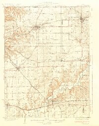
1932 Map of Mackinaw
USGS Topo · Published 1932About this map
The Mackinaw River winds through the heart of this Central Illinois landscape, defining a terrain of carved valleys and fertile uplands. In the early 1930s, the region was a critical junction for rail travel and commerce, anchored by the community of Eureka and the bustling transit point at Pekin Junction. The map captures a high density of rural social infrastructure, with dozens of family-named schools and local houses of worship, such as the Mennonite Ch and Union Ch, serving as the anchors for agrarian life.
Find a feature on this map
119 named features on this map. Tap any name to fly to it.
Don’t see what you’re looking for? This feature index may not catch every label — zoom into the map to look around manually.
Map Details
Editions of this 1932 Mackinaw Map
2 editions found
Other maps of this area

1893 · Metamora
USGS Topo · 1:62,500

1893 · Dunlap
USGS Topo · 1:62,500

1898 · Dunlap
USGS Topo · 1:62,500

1905 · Peoria
USGS Topo · 1:62,500

1927 · Peoria
USGS Topo · 1:62,500

1927 · Danvers
USGS Topo · 1:62,500

1928 · Mackinaw
USGS Topo · 1:62,500

1930 · Danvers
USGS Topo · 1:62,500

1932 · Mackinaw
USGS Topo · 1:62,500

1932 · Dunlap
USGS Topo · 1:62,500