
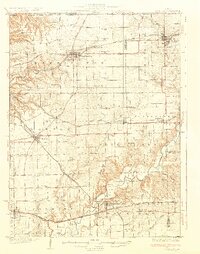
1932 Map of Mackinaw
USGS Topo · Published 1932About this map
Washington and Morton serve as the primary hubs in this Central Illinois landscape, which is defined by a dense lattice of competing rail lines and rural school districts during the early 1930s. The Mackinaw River winds through the southern portion of the sheet, crossed by the Tyrrell Bridge and the Vaughn Bridge, while the Mackinaw Sanitarium stands near the village of Mackinaw. The transport network is particularly complex, featuring the Illinois Traction System (Electric) alongside major steam lines like the Atchison Topeka and Santa Fe. This era represents the peak of the rural school system, with nearly every section of the township supporting institutions such as Science Hill Sch, Maple Grove Sch, and Liberty Sch. Religious life is anchored by the Mennonite Ch and Union Ch, while settlements like Allentown and Deer Creek show the close-knit spacing of agricultural communities tied to the Chicago and Alton and other rail corridors.
Find a feature on this map
88 named features on this map. Tap any name to fly to it.
Don’t see what you’re looking for? This feature index may not catch every label — zoom into the map to look around manually.
Map Details
Editions of this 1932 Mackinaw Map
2 editions found
Other maps of this area

1893 · Metamora
USGS Topo · 1:62,500

1893 · Dunlap
USGS Topo · 1:62,500

1898 · Dunlap
USGS Topo · 1:62,500

1905 · Peoria
USGS Topo · 1:62,500

1927 · Peoria
USGS Topo · 1:62,500

1927 · Danvers
USGS Topo · 1:62,500

1928 · Mackinaw
USGS Topo · 1:62,500

1930 · Danvers
USGS Topo · 1:62,500

1932 · Dunlap
USGS Topo · 1:62,500

1933 · Dunlap
USGS Topo · 1:62,500