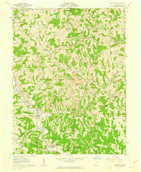
1961 Map of Macksburg
USGS Topo · Published 1963About this map
Pennsylvania RR railroad tracks follow the valley of West Fork Duck Creek, anchoring a series of small village settlements in this corner of Noble and Washington counties. During the early 1960s, the landscape around Dexter City and Macksburg reveals an economy defined by extraction and transport, with numerous Gas Wells and active Strip Mine operations scattered throughout the ridges. Genealogical interest is high given the density of family-named burial sites like Harris Cem, Hesson Cem, and McGinnis Cem, which are preserved alongside local landmarks like Ogles Ridge Ch. The terrain is deeply dissected by drainages such as Buffalo Run and Goose Creek, creating a complex network of narrow hollows where smaller hamlets like Moundsville and South Olive are situated.
Find a feature on this map
40 named features on this map. Tap any name to fly to it.
Don’t see what you’re looking for? This feature index may not catch every label — zoom into the map to look around manually.
Map Details
Editions of this 1961 Macksburg Map
3 editions found
Other maps of this area

1903 · Macksburg
USGS Topo · 1:62,500

1905 · Macksburg
USGS Topo · 1:62,500

1909 · Caldwell
USGS Topo · 1:62,500

1909 · Summerfield
USGS Topo · 1:62,500

1911 · Cumberland
USGS Topo · 1:62,500

1911 · Summerfield
USGS Topo · 1:62,500

1912 · Caldwell
USGS Topo · 1:62,500

1949 · Clarksburg
USGS Topo · 1:250,000

1956 · Clarksburg
USGS Topo · 1:250,000

1961 · Clarksburg
USGS Topo · 1:250,000