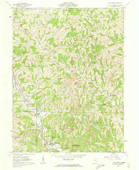
1961 Map of Macksburg
USGS Topo · Published 1963About this map
Duck Creek serves as the central geographic axis for this portion of the Ohio hill country during the early 1960s, carving a winding path through the borderlands of Noble and Washington counties. The landscape is defined by its deep dissection, where numerous small settlements like Dexter City and South Olive are tucked into the narrow valleys. A significant industrial presence is visible in the north, where Strip Mine operations and a Pipeline cut across the high ridges, contrasting with the traditional rural character of places like Fulda.
Find a feature on this map
39 named features on this map. Tap any name to fly to it.
Don’t see what you’re looking for? This feature index may not catch every label — zoom into the map to look around manually.
Map Details
Editions of this 1961 Macksburg Map
3 editions found
Other maps of this area

1903 · Macksburg
USGS Topo · 1:62,500

1905 · Macksburg
USGS Topo · 1:62,500

1909 · Caldwell
USGS Topo · 1:62,500

1909 · Summerfield
USGS Topo · 1:62,500

1911 · Cumberland
USGS Topo · 1:62,500

1911 · Summerfield
USGS Topo · 1:62,500

1912 · Caldwell
USGS Topo · 1:62,500

1949 · Clarksburg
USGS Topo · 1:250,000

1956 · Clarksburg
USGS Topo · 1:250,000

1961 · Clarksburg
USGS Topo · 1:250,000