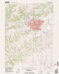
1997 Map of Macomb
USGS Topo · Published 1999About this map
Western Illinois University anchors the northwestern reaches of this West-Central Illinois landscape, where the academic campus meets the residential expansion of Macomb. The city serves as a hub of civic infrastructure, concentrated around the central Courthouse, Post Office, and City Hall. To the north and west, the terrain is defined by the winding course of the East Fork La Moine River and its tributaries, including Spring Creek and Killjordan Creek.
Find a feature on this map
43 named features on this map. Tap any name to fly to it.
Don’t see what you’re looking for? This feature index may not catch every label — zoom into the map to look around manually.
Map Details
Editions of this 1997 Macomb Map
2 editions found
Other maps of this area

1912 · Macomb
USGS Topo · 1:62,500

1913 · Colchester
USGS Topo · 1:62,500

1914 · Macomb
USGS Topo · 1:62,500

1916 · Good Hope
USGS Topo · 1:62,500

1918 · La Harpe
USGS Topo · 1:62,500

1918 · Good Hope
USGS Topo · 1:62,500

1958 · Burlington
USGS Topo · 1:250,000

1961 · Burlington
USGS Topo · 1:250,000

1963 · Burlington
USGS Topo · 1:250,000
1974 · Doddsville
USGS Topo · 1:24,000