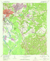
1956 Map of Macon East
USGS Topo · Published 1973About this map
Ocmulgee National Monument anchors this 1956 landscape, preserving ancient history just east of the growing Macon city limits. This survey captures a significant period of expansion, showing the sprawling industrial activity of multiple Strip Mines and the Brick Kilns along the eastern banks of the Ocmulgee River. The map meticulously documents the transition from urban to rural, where historical sites like Ft Hawkins and the Ft Hawkins Cem stand near the busy corridors of the Central of Georgia and Seaboard Coast Line railroads.
Find a feature on this map
57 named features on this map. Tap any name to fly to it.
Don’t see what you’re looking for? This feature index may not catch every label — zoom into the map to look around manually.
Map Details
Editions of this 1956 Macon East Map
4 editions found
Other maps of this area

1956 · Gordon
USGS Topo · 1:62,500

1956 · Warner Robins
USGS Topo · 1:62,500

1956 · Jeffersonville
USGS Topo · 1:62,500

1956 · Macon West
USGS Topo · 1:24,000

1956 · Macon East
USGS Topo · 1:24,000

1956 · Macon
USGS Topo · 1:62,500

1957 · Macon
USGS Topo · 1:250,000

1958 · Macon
USGS Topo · 1:250,000

1964 · Macon
USGS Topo · 1:250,000
1973 · Macon NE
USGS Topo · 1:24,000