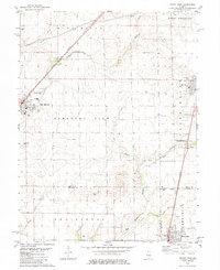
1982 Map of Macon West
USGS Topo · Published 1984About this map
Agricultural lands across central Illinois define this landscape where the borders of Macon, Christian, and Shelby counties converge. The villages of Blue Mound and Macon anchor the northern half of the sheet, connected by the diagonal route of the Norfolk and Western railroad. To the south, the village of Moweaqua sits along the Illinois Central Gulf line, reflecting the late 20th-century importance of rail transport for moving grain and local goods.
Find a feature on this map
43 named features on this map. Tap any name to fly to it.
Don’t see what you’re looking for? This feature index may not catch every label — zoom into the map to look around manually.
Map Details
Editions of this 1982 Macon West Map
2 editions found
Other maps of this area

1929 · Decatur
USGS Topo · 1:62,500

1933 · Decatur
USGS Topo · 1:62,500

1949 · Dalton City
USGS Topo · 1:62,500

1952 · Assumption
USGS Topo · 1:62,500

1954 · Niantic
USGS Topo · 1:62,500

1958 · Decatur
USGS Topo · 1:250,000

1961 · Decatur
USGS Topo · 1:250,000

1967 · Decatur
USGS Topo · 1:24,000

1974 · Willeys
USGS Topo · 1:24,000

1982 · Harristown
USGS Topo · 1:24,000