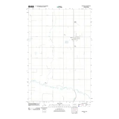
2011 Map of Maddock
USGS Topo · Published 2011About this map
Maddock serves as the central hub of this Benson County landscape, where the gridiron street pattern of the town meets the sprawling agricultural sections of the North Dakota prairie. The community is anchored by local aviation and memorial sites, including the Maddock Municipal Airport, Rices Airpark, and the Zion Cemetery. To the south, the terrain is defined by the winding course of the Sheyenne River, which carves a distinct path through the township alongside the Big Coulee. The influence of early transportation is evident in the street names within the town proper, such as Railway Ave and Viking Ave, reflecting the regional heritage and the importance of rail access to the plains economy. Outside the town limits, a precise network of section roads like 47th Ave NE and 38th St NE organizes the surrounding farmland.
Find a feature on this map
27 named features on this map. Tap any name to fly to it.
Don’t see what you’re looking for? This feature index may not catch every label — zoom into the map to look around manually.
Map Details
Editions of this 2011 Maddock Map
This is the sole edition of this map. No revisions or reprints were ever made.
Other maps of this area

1932 · Flora
USGS Topo · 1:62,500

1943 · Maddock
USGS Topo · 1:62,500

1945 · Maddock
USGS Topo · 1:62,500

1951 · Black Hammer Hill
USGS Topo · 1:24,000

1951 · Flora
USGS Topo · 1:24,000

1951 · Maddock
USGS Topo · 1:24,000
1951 · Heimdal
USGS Topo · 1:24,000

1951 · Hesper
USGS Topo · 1:24,000
1951 · Hamberg
USGS Topo · 1:24,000

1951 · Flora
USGS Topo · 1:62,500