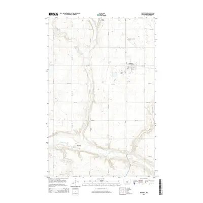
2014 Map of Maddock
USGS Topo · Published 2014About this map
Maddock serves as the primary hub of activity in this Benson County landscape, where a grid of streets including Railway Ave and Eastern Ave anchors the community's residential and commercial center. This 2014 survey documents the enduring agricultural and aviation character of the region, featuring multiple local flight facilities such as Maddock Municipal Airport, Sorlie Airport, and Rices Airpark. The natural drainage of the North Dakota prairie is clearly defined by the winding course of the Sheyenne River and the prominent Big Coulee cutting through the western sections. Local history and genealogy researchers will find the locations of Zion Cem and N Viking Cem essential for mapping early family sites and community heritage. The map details a well-ordered township system of section lines, with numbered roads like 38th St NE and 47th Ave NE providing the framework for the area's rural transit network.
Find a feature on this map
28 named features on this map. Tap any name to fly to it.
Don’t see what you’re looking for? This feature index may not catch every label — zoom into the map to look around manually.
Map Details
Editions of this 2014 Maddock Map
This is the sole edition of this map. No revisions or reprints were ever made.
Other maps of this area

1932 · Flora
USGS Topo · 1:62,500

1943 · Maddock
USGS Topo · 1:62,500

1945 · Maddock
USGS Topo · 1:62,500

1951 · Black Hammer Hill
USGS Topo · 1:24,000

1951 · Flora
USGS Topo · 1:24,000

1951 · Maddock
USGS Topo · 1:24,000
1951 · Heimdal
USGS Topo · 1:24,000

1951 · Hesper
USGS Topo · 1:24,000
1951 · Hamberg
USGS Topo · 1:24,000

1951 · Flora
USGS Topo · 1:62,500