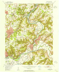
1953 Map of Madeira
USGS Topo · Published 1955About this map
The Little Miami River snakes through the center of this map, serving as the physical divide between Hamilton and Clermont counties. The landscape shows a post-war suburban shift as established communities like Madeira, Milford, and Terrace Park expand alongside significant institutional landmarks. Educational and religious sites are numerous, including the Cincinnati Country Day School, Sacred Heart Novitiate, and several neighborhood cemeteries like Hopewell and St. Andrews.
Find a feature on this map
83 named features on this map. Tap any name to fly to it.
Don’t see what you’re looking for? This feature index may not catch every label — zoom into the map to look around manually.
Map Details
Editions of this 1953 Madeira Map
This is the sole edition of this map. No revisions or reprints were ever made.
Other maps of this area

1898 · East Cincinnati
USGS Topo · 1:62,500

1904 · Mason
USGS Topo · 1:62,500

1906 · Mason
USGS Topo · 1:62,500

1914 · East Cincinnati
USGS Topo · 1:62,500

1914 · Batavia
USGS Topo · 1:48,000

1914 · Morrow
USGS Topo · 1:62,500

1916 · Batavia
USGS Topo · 1:62,500

1916 · Morrow
USGS Topo · 1:62,500

1952 · Newport
USGS Topo · 1:24,000

1953 · Withamsville
USGS Topo · 1:24,000