1946 Map of Madera
USGS Topo · Published 1954About this map
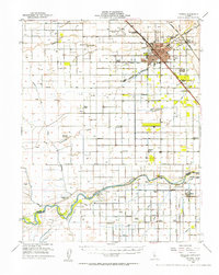
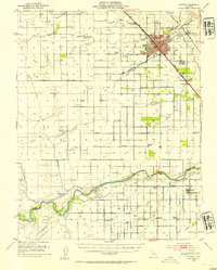
Agricultural development and irrigation networks define the landscape of the Central Valley in the mid-1940s, centered on the growing hub of Madera. The map captures a transition toward mechanized farming and aviation, with the Madera Municipal Airport situated north of the city and a Winery located along the Southern Pacific Railroad. This era is marked by a reliance on an intricate system of waterways, including the Madera Canal and the San Joaquin River, which provided the necessary water for established properties like the Gravelly Ford Ranch and Bonita Ranch. The social fabric of the rural county is visible through a high density of small district schools, such as the Ripperdan School, Howard School, and Sharon Bible School. On the southern edge of the survey, the settlement of Biola serves as a secondary rail and irrigation point along the Enterprise Canal.
Find a feature on this map
48 named features on this map. Tap any name to fly to it.
Don’t see what you’re looking for? This feature index may not catch every label — zoom into the map to look around manually.
Map Details
Editions of this 1946 Madera Map
2 editions found
Other maps of this area

1912 · Mariposa
USGS Topo · 1:125,000

1916 · Berenda
USGS Topo · 1:31,680

1918 · Chowchilla
USGS Topo · 1:31,680

1918 · Berenda
USGS Topo · 1:31,680

1920 · Kismet
USGS Topo · 1:31,680

1920 · Bonita Ranch
USGS Topo · 1:31,680

1921 · Daulton
USGS Topo · 1:31,680

1921 · Mendota
USGS Topo · 1:31,680

1921 · Bonita Ranch
USGS Topo · 1:31,680

1922 · Gregg
USGS Topo · 1:31,680