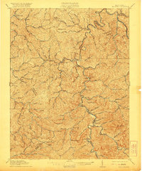
1911 Map of Madison
USGS Topo · Published 1921About this map
Madison and Danville serve as central hubs in this early 20th-century survey of the coal and timber regions of southwestern West Virginia. The landscape is defined by the winding course of the Little Coal River and the Coal River, which facilitated the movement of resources through the Appalachians. Industrial infrastructure is prominent, particularly the rail lines of the Chesapeake and Ohio River and engineering feats like Blue Tom Tunnel and Pinnacle Tunnel. Beyond the industrial corridors, the map reveals a high density of small rural settlements including Griffithsville, Woodville, and Uneeda. The topography is a complex network of steep ridges and hollows, such as High Hollow and Fawn Hollow, punctuated by peaks like Brushy Knob. Small community landmarks, including the Olive Branch Church and numerous rural schools, provide critical points of reference for genealogists tracing family locations before the mid-century expansion of modern roadways.
Find a feature on this map
105 named features on this map. Tap any name to fly to it.
Don’t see what you’re looking for? This feature index may not catch every label — zoom into the map to look around manually.
Map Details
Editions of this 1911 Madison Map
2 editions found

Other maps of this area

1887 · Warfield
USGS Topo · 1:125,000

1891 · Oceana
USGS Topo · 1:125,000

1891 · Warfield
USGS Topo · 1:125,000

1892 · Huntington
USGS Topo · 1:125,000

1893 · Oceana
USGS Topo · 1:125,000

1898 · Huntington
USGS Topo · 1:125,000

1898 · Oceana
USGS Topo · 1:125,000

1899 · Charleston
USGS Topo · 1:125,000

1902 · Milton
USGS Topo · 1:62,500

1902 · Midkiff
USGS Topo · 1:62,500