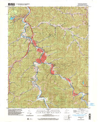
1996 Map of Madison
USGS Topo · Published 2003About this map
The Little Coal River and Pond Fork dictate the settlement patterns of this West Virginia landscape, with the towns of Madison and Danville serving as central hubs at their confluence. This 1996 survey illustrates the deep integration of industry and community, where CSX Transportation rail lines and extensive gas fields weave between family-named hollows and cemeteries. For genealogists, the map is remarkably dense with burial grounds, including Madison Memorial Park (Cem), Washington Heights Cem, and the Rock Creek Sch (Cem). Residential areas like Washington Heights and South Madison are balanced by industrial markers such as a Quarry and various gas wells. Notable landmarks include the local Golf Course and the Washington, Scott, and Crook district boundaries, reflecting the civic organization of Boone County at the close of the century.
Find a feature on this map
77 named features on this map. Tap any name to fly to it.
Don’t see what you’re looking for? This feature index may not catch every label — zoom into the map to look around manually.
Map Details
Editions of this 1996 Madison Map
This is the sole edition of this map. No revisions or reprints were ever made.
Other maps of this area

1891 · Oceana
USGS Topo · 1:125,000

1893 · Oceana
USGS Topo · 1:125,000

1898 · Oceana
USGS Topo · 1:125,000

1899 · Charleston
USGS Topo · 1:125,000

1909 · Peytona
USGS Topo · 1:48,000

1910 · Bald Knob
USGS Topo · 1:48,000

1911 · Peytona
USGS Topo · 1:62,500

1911 · Madison
USGS Topo · 1:62,500

1912 · Bald Knob
USGS Topo · 1:62,500

1913 · Logan
USGS Topo · 1:62,500