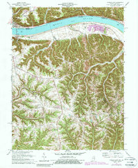
1971 Map of Madison East
USGS Topo · Published 1987About this map
The Ohio River cuts a wide path between Indiana and Kentucky, serving as the dominant geographic and economic feature of this river valley landscape. On the Indiana side, the city of Madison sits below the prominent Telegraph Hill, while across the water in Kentucky, the town of Milton is framed by a network of steep ridges and deep hollows like Hardscrabble Hollow. This era shows a transition in land use, with established riverside landmarks like the Radio Tower (WORX) and various boat ramps alongside newer developments such as the Celtic Grove Campground. The Kentucky interior is defined by high ground, including Fairview Ridge and Freeport Ridge, where small rural communities are anchored by centers of faith and memory like St Peters Ch, Hopewell Ch, and Moffett Cem. The map captures the complex drainage patterns of the region, where numerous creeks like Canip Creek and Locust Creek have carved the terrain into its distinctive finger-like ridges.
Find a feature on this map
42 named features on this map. Tap any name to fly to it.
Don’t see what you’re looking for? This feature index may not catch every label — zoom into the map to look around manually.
Map Details
Editions of this 1971 Madison East Map
4 editions found
Other maps of this area

1939 · Bethlehem
USGS Topo · 1:24,000

1939 · Madison West
USGS Topo · 1:24,000

1943 · Brooksburg
USGS Topo · 1:24,000

1948 · Bethlehem
USGS Topo · 1:24,000

1948 · Madison West
USGS Topo · 1:24,000

1952 · Campbellsburg
USGS Topo · 1:24,000

1953 · Madison West
USGS Topo · 1:24,000

1953 · Bedford
USGS Topo · 1:24,000

1953 · Carrollton
USGS Topo · 1:24,000

1953 · Madison East
USGS Topo · 1:24,000