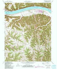
1971 Map of Madison East
USGS Topo · Published 1994About this map
The Ohio River carves a deep valley at the border of Indiana and Kentucky, separating the riverfront city of Madison from the town of Milton. This 1971 revision captures the transition from the industrial and municipal center of Madison, marked by the Radio Tower (WORX) and extensive infrastructure, to the deeply dissected ridges of the Kentucky shore. Settlement patterns follow the high ground of Fairview Ridge and Kings Ridge, where a network of rural congregations including St Peters Ch and Hopewell Ch define the local community. The topography is characterized by steep ravines and distinctive landmarks like Big Cedar Cliffs. Further south, the landscape becomes increasingly rural near the settlements of McKinney and Monitor, providing a clear view of the homesteads and local roads like Telegraph Hill Road that served the area before modern expansions.
Find a feature on this map
45 named features on this map. Tap any name to fly to it.
Don’t see what you’re looking for? This feature index may not catch every label — zoom into the map to look around manually.
Map Details
Editions of this 1971 Madison East Map
4 editions found
Other maps of this area

1939 · Bethlehem
USGS Topo · 1:24,000

1939 · Madison West
USGS Topo · 1:24,000

1943 · Brooksburg
USGS Topo · 1:24,000

1948 · Bethlehem
USGS Topo · 1:24,000

1948 · Madison West
USGS Topo · 1:24,000

1952 · Campbellsburg
USGS Topo · 1:24,000

1953 · Madison West
USGS Topo · 1:24,000

1953 · Bedford
USGS Topo · 1:24,000

1953 · Carrollton
USGS Topo · 1:24,000

1953 · Madison East
USGS Topo · 1:24,000