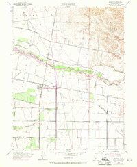
1953 Map of Madison
USGS Topo · Published 1970About this map
The Southern Pacific railroad corridor anchors the small community of Madison in this mid-century portrait of Yolo County. The landscape is defined by its complex water management systems, where the Cache Creek channel feeds into the West Adams Canal and Adams Canal, while Moore Dam controls the flow into the Winters Canal. This intersection of natural hydrology and engineering reflects the area's agricultural foundation, visible in the sprawling Grant Boundary lines that segment the valley floor south of the Dunnigan Hills. Local history is preserved in landmarks such as the Cottonwood Cemetery and rural education sites like Clover Sch and the Mt Pleasant District School. To the northeast, the terrain transitions into the distinct topography of Hungry Hollow, while industry is represented by the extensive Gravel Pits along the creek bed and the aviation facilities at Weggers Airport.
Find a feature on this map
20 named features on this map. Tap any name to fly to it.
Don’t see what you’re looking for? This feature index may not catch every label — zoom into the map to look around manually.
Map Details
Editions of this 1953 Madison Map
4 editions found
Other maps of this area

1905 · Esparto
USGS Topo · 1:24,000

1907 · Dunnigan
USGS Topo · 1:62,500

1907 · Woodland
USGS Topo · 1:62,500

1915 · Yolo
USGS Topo · 1:31,680

1915 · Ronda
USGS Topo · 1:31,680

1915 · Merritt
USGS Topo · 1:31,680

1916 · Jacobs Corner
USGS Topo · 1:31,680

1916 · Zamora
USGS Topo · 1:31,680

1916 · Winters
USGS Topo · 1:31,680

1916 · Esparto
USGS Topo · 1:31,680