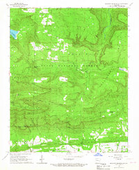
1966 Map of Magazine Mountain NE
USGS Topo · Published 1967About this map
Magazine Mountain dominates this mid-1960s landscape, providing a high-elevation backdrop for the rural communities and natural areas along the border of Logan, Yell, and Johnson Counties. The rugged interior is primarily occupied by the Ozark National Forest, featuring distinct ridges such as Rich Mountain, Huckleberry Mountain, and North Pointer Ridge. Along the southern edge, the Chicago Rock Island and Pacific railroad follows the valley of Piney Creek, passing through the small settlement of Ferguson.
Find a feature on this map
47 named features on this map. Tap any name to fly to it.
Don’t see what you’re looking for? This feature index may not catch every label — zoom into the map to look around manually.
Map Details
Editions of this 1966 Magazine Mountain NE Map
2 editions found
Other maps of this area

1879 · Mountain Home
USGS Topo · 1:62,500

1887 · Magazine Mountain #1
USGS Topo · 1:62,500

1887 · Magazine Mountain #4
USGS Topo · 1:62,500

1887 · Magazine Mountain
USGS Topo · 1:62,500

1888 · Dardanelle #2
USGS Topo · 1:62,500

1888 · Dardanelle #3
USGS Topo · 1:62,500

1890 · Magazine Mountain
USGS Topo · 1:125,000

1890 · Dardanelle
USGS Topo · 1:125,000

1956 · Russellville
USGS Topo · 1:250,000
1961 · Scranton
USGS Topo · 1:24,000