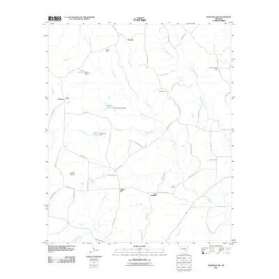
2011 Map of Magnolia NW
USGS Topo · Published 2011About this map
Smackover Creek and its many tributaries, including Blake Creek and Crooked Creek, define the rural landscape of Columbia County in this detailed 2011 topographic study. The area is marked by a legacy of resource extraction, with the North Stephens Oil and Gas Field in the northeast and the College Hill Oil and Gas Field to the southwest. These industrial zones sit alongside small, established communities such as Saint Matthews and College Hill.
Find a feature on this map
56 named features on this map. Tap any name to fly to it.
Don’t see what you’re looking for? This feature index may not catch every label — zoom into the map to look around manually.
Map Details
Editions of this 2011 Magnolia NW Map
This is the sole edition of this map. No revisions or reprints were ever made.
Other maps of this area

1901 · Gurdon
USGS Topo · 1:125,000

1953 · El Dorado
USGS Topo · 1:250,000

1957 · El Dorado
USGS Topo · 1:250,000

1958 · El Dorado
USGS Topo · 1:250,000

1960 · El Dorado
USGS Topo · 1:250,000

1966 · Village
USGS Topo · 1:24,000

1968 · Lamartine
USGS Topo · 1:24,000

1968 · Waldo
USGS Topo · 1:24,000
1968 · Magnolia
USGS Topo · 1:24,000
1969 · Stephens
USGS Topo · 1:24,000