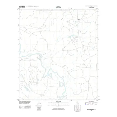
2010 Map of Magnolia Springs
USGS Topo · Published 2010About this map
Magnolia Springs sits amidst the timber and water resources of Jasper County, characterized by a grid of local roads and state routes. The area is defined by its relationship to the water, where the winding course of the Neches River creates a complex system of oxbows and wetlands along the southwestern edge of the quadrangle. Significant state infrastructure is visible at the Magnolia Springs State Nursery, located just north of Mount Union, which supports the region's long-standing forestry interests. Industry and nature converge near the river valley, where the Joes Lake Oil Field operates in proximity to multiple tributaries like Mill Creek and Turner Branch. This landscape highlights a balance between active resource extraction and conservation efforts in East Texas during the early 21st century, as rural settlements remained tied to the land and the networks of the FM 1013 and FM 1005 corridors.
Find a feature on this map
35 named features on this map. Tap any name to fly to it.
Don’t see what you’re looking for? This feature index may not catch every label — zoom into the map to look around manually.
Map Details
Editions of this 2010 Magnolia Springs Map
This is the sole edition of this map. No revisions or reprints were ever made.
Other maps of this area

1952 · Lake Charles
USGS Topo · 1:250,000

1954 · Lake Charles
USGS Topo · 1:250,000

1954 · Beaumont
USGS Topo · 1:250,000

1955 · Roganville
USGS Topo · 1:62,500

1955 · Curtis
USGS Topo · 1:62,500

1957 · Beaumont
USGS Topo · 1:250,000

1958 · Spurger
USGS Topo · 1:62,500

1958 · Kirbyville
USGS Topo · 1:62,500

1984 · Beaumont
USGS Topo · 1:250,000

1984 · Potato Patch Lake
USGS Topo · 1:24,000