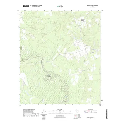
2019 Map of Magnolia Springs
USGS Topo · Published 2019About this map
Magnolia Springs and Mount Union anchor this section of Southeast Texas, where the landscape is defined by the winding course of the Neches River. The river forms a natural boundary between Jasper and Tyler Counties, its floodplain protected within the Big Thicket National Preserve. This area is characterized by dense forest and numerous watercourses, including Mill Cr, Walker Br, and Turner Branch, which feed into the primary river system. Local landmarks like Magnolia Springs Lake and a network of rural roads such as FM 1013 connect these small communities. The presence of Temple Inland Rd suggests the historical and economic significance of timber management in this portion of the Piney Woods. This 2019 survey provides a precise look at the contemporary interface between conservation lands and long-standing rural settlements.
Find a feature on this map
43 named features on this map. Tap any name to fly to it.
Don’t see what you’re looking for? This feature index may not catch every label — zoom into the map to look around manually.
Map Details
Editions of this 2019 Magnolia Springs Map
This is the sole edition of this map. No revisions or reprints were ever made.
Other maps of this area

1952 · Lake Charles
USGS Topo · 1:250,000

1954 · Lake Charles
USGS Topo · 1:250,000

1954 · Beaumont
USGS Topo · 1:250,000

1955 · Roganville
USGS Topo · 1:62,500

1955 · Curtis
USGS Topo · 1:62,500

1957 · Beaumont
USGS Topo · 1:250,000

1958 · Spurger
USGS Topo · 1:62,500

1958 · Kirbyville
USGS Topo · 1:62,500

1984 · Beaumont
USGS Topo · 1:250,000

1984 · Potato Patch Lake
USGS Topo · 1:24,000