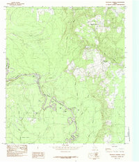
1984 Map of Magnolia Springs
USGS Topo · Published 1985About this map
Magnolia Springs and Mount Union anchor the eastern upland elevations in this 1978 field-checked landscape along the boundary of Jasper and Tyler counties. The Neches River dictates the region's geography, carving a winding path through the Big Thicket National Preserve. This protected corridor preserves a complex wetland ecosystem, characterized by an intricate network of oxbow lakes and sloughs created by the river's shifting course over time. Notable examples include the deep curves of Hoard Bend and a string of named water bodies such as Old River Lake, Nasty Lake, and Long Lake. To the west, the river creates unique landforms like Ramer Island and feeds into Gum Slough and Turner Branch. Small settlements like River Acres occupy the periphery of the river’s floodplain, illustrating the long-standing relationship between local residents and the river's unpredictable drainage patterns through the piney woods of East Texas.
Find a feature on this map
23 named features on this map. Tap any name to fly to it.
Don’t see what you’re looking for? This feature index may not catch every label — zoom into the map to look around manually.
Map Details
Editions of this 1984 Magnolia Springs Map
This is the sole edition of this map. No revisions or reprints were ever made.
Other maps of this area

1952 · Lake Charles
USGS Topo · 1:250,000

1954 · Lake Charles
USGS Topo · 1:250,000

1954 · Beaumont
USGS Topo · 1:250,000

1955 · Roganville
USGS Topo · 1:62,500

1955 · Curtis
USGS Topo · 1:62,500

1957 · Beaumont
USGS Topo · 1:250,000

1958 · Spurger
USGS Topo · 1:62,500

1958 · Kirbyville
USGS Topo · 1:62,500

1984 · Beaumont
USGS Topo · 1:250,000

1984 · Potato Patch Lake
USGS Topo · 1:24,000