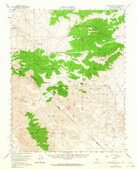
1957 Map of Magruder Mtn
USGS Topo · Published 1964About this map
Palmetto Mountains and the northern reaches of Death Valley define this mid-century high-desert landscape straddling the Nevada-California border. The map documents an area defined by isolated water sources and mining prospects, with activity centered around Sylvania Mine and the Blue Dick Mine. This territory was vital for mineral exploration in Esmeralda County, where prospectors relied on a network of springs such as Cucamungo Spring, Pigeon Spring, and Uncle Sam Spring.
Find a feature on this map
43 named features on this map. Tap any name to fly to it.
Don’t see what you’re looking for? This feature index may not catch every label — zoom into the map to look around manually.
Map Details
Editions of this 1957 Magruder Mtn Map
2 editions found
Other maps of this area

1898 · Silver Peak
USGS Topo · 1:125,000

1900 · Silver Peak
USGS Topo · 1:125,000

1908 · Lida
USGS Topo · 1:250,000

1913 · Lida
USGS Topo · 1:250,000

1945 · Goldfield
USGS Topo · 1:125,000

1954 · Goldfield
USGS Topo · 1:250,000

1955 · Goldfield
USGS Topo · 1:250,000

1957 · Magruder Mtn
USGS Topo · 1:62,500

1957 · Ubehebe Crater
USGS Topo · 1:62,500

1958 · Goldfield
USGS Topo · 1:250,000