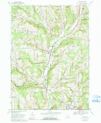
1969 Map of Maine
USGS Topo · Published 1990About this map
Nanticoke Creek flows through the center of this rural landscape, carving a valley that dictated the growth of settlements like Union Center and Maine (NM 939). By the late 1960s, the area remained largely agricultural and forested, though the southern edge shows the suburban expansion of Endwell with the presence of large educational facilities like Maine-Endwell High Sch. The map preserves a dense network of local history, marking numerous family and community burial grounds such as Zimmer Cem, Allentown Cem, and Harrington Cem.
Find a feature on this map
43 named features on this map. Tap any name to fly to it.
Don’t see what you’re looking for? This feature index may not catch every label — zoom into the map to look around manually.
Map Details
Editions of this 1969 Maine Map
3 editions found
Other maps of this area

1901 · Apalachin
USGS Topo · 1:62,500

1903 · Harford
USGS Topo · 1:62,500

1904 · Binghamton
USGS Topo · 1:62,500

1904 · Greene
USGS Topo · 1:62,500

1904 · Apalachin
USGS Topo · 1:62,500

1906 · Catatonk
USGS Topo · 1:125,000

1934 · Castle Creek
USGS Topo · 1:24,000

1935 · Binghamton West
USGS Topo · 1:24,000

1942 · Binghamton West
USGS Topo · 1:31,680

1942 · Castle Creek
USGS Topo · 1:31,680