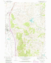
1968 Map of Malad City East
USGS Topo · Published 1984About this map
Malad City sits at the western edge of this 1960s survey, serving as the central hub for the surrounding agricultural and ranching landscape of the Malad Valley. The Union Pacific railroad line runs north-south through the valley, anchoring the local economy alongside features like the County Fairgrounds and various Storage Bins near the city limits. The terrain rises sharply to the east into the Caribou National Forest, where a series of numbered drainages including First Creek, Second Creek, and Third Creek carve through the mountains. Water management is a defining characteristic of this area, evidenced by the Deep Creek Reservoir, Upper Deep Creek Reservoir, and Weston Creek Reservoir. These man-made bodies of water, along with named canyons like Maple Hollow and Susan Hollow, illustrate how early Idaho settlers and engineers adapted to the arid climate of the eastern Great Basin.
Find a feature on this map
34 named features on this map. Tap any name to fly to it.
Don’t see what you’re looking for? This feature index may not catch every label — zoom into the map to look around manually.
Map Details
Editions of this 1968 Malad City East Map
2 editions found
Other maps of this area

1954 · Pocatello
USGS Topo · 1:250,000

1958 · Pocatello
USGS Topo · 1:250,000

1968 · Samaria
USGS Topo · 1:24,000

1968 · Malad Summit
USGS Topo · 1:24,000

1968 · Oxford
USGS Topo · 1:24,000

1968 · Malad City West
USGS Topo · 1:24,000

1968 · Malad City East
USGS Topo · 1:24,000
1968 · Henderson Creek
USGS Topo · 1:24,000

1968 · Clifton
USGS Topo · 1:24,000
1968 · Weston Canyon
USGS Topo · 1:24,000