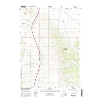
2017 Map of Malad Summit
USGS Topo · Published 2017About this map
Malad Summit marks a high point in the terrain where the North and South forks of the Interstate-15 corridor navigate the transition between Bannock and Oneida counties. This high mountain pass is defined by the Caribou National Forest, which spans much of the eastern and western portions of the quadrangle. Water management and natural springs are central to the landscape, anchored by the Devil Creek Reservoir and numerous perennial sources such as Curly Jack Spring, Cherry Spring, and Heath Spring.
Find a feature on this map
48 named features on this map. Tap any name to fly to it.
Don’t see what you’re looking for? This feature index may not catch every label — zoom into the map to look around manually.
Map Details
Editions of this 2017 Malad Summit Map
This is the sole edition of this map. No revisions or reprints were ever made.
Other maps of this area

1954 · Pocatello
USGS Topo · 1:250,000

1958 · Pocatello
USGS Topo · 1:250,000

1968 · Malad Summit
USGS Topo · 1:24,000

1968 · Oxford
USGS Topo · 1:24,000

1968 · Malad City West
USGS Topo · 1:24,000

1968 · Downey West
USGS Topo · 1:24,000

1968 · Malad City East
USGS Topo · 1:24,000

1968 · Wakley Peak
USGS Topo · 1:24,000

1968 · Clifton
USGS Topo · 1:24,000
1968 · Downey East
USGS Topo · 1:24,000